Meeting History of the Grant Road Coalition -Central Segments
May 9, 2024 Minutes
May 9, 2024 Planning Paper- Information and Agenda
White Paper - Published March 30, 2023
GRANT ROAD COALITION "Central Segments" WHITE PAPER
for PHASES 5/6 of the Grant Road Project - March 30, 2023
To see the White Paper from the neighbors of the "Central Segments" go to:
http://www.grantroadcoalition.com/56-white-paper.html
May 17, 2023 - Minutes, Meeting with TDOT,PSOMAS and PDSD
MINUTES GRANT ROAD COALITION May 17, 2023
Present:
NUNA: M. Atwood, A. Paxton, P. Weber
JPNA: J. Osuna, C. Nichols, J. Daniels, S. Lorch, C. Doklan, E. Posthumus, R. Schlanger
SAMOS: B. Miller, D. Ceron
Catalina Vista: J. Fischer
PDSD: D. Bursack, C. Struve, DTM: B. Roggenthen PSOMAS: R. Cheney, A. Angel
Overlay Process
Community engagement with Grant Road Task Force will begin in September 2023. Sarah Studd (of Mtn/First neighborhood) is the representative for Central Segments. DTM will contact the Coalition before the task force meeting.
Construction Cost
The construction cost is $35 million.
$50 million has been earmarked for acquisition of properties to initiate. DTM is waiting for RTA approval on this amount.
Linear Park
Art
1% of the total construction budget ($350,000) is required for art. A committee of at least 7 members meets with artists and reviews their submissions and selects the artist. Neighborhoods may request to be on the committee. B. Roggenthen suggests sites for the art where there is room and the committee, artist, and DTM will jointly decide the location.
Present:
NUNA: M. Atwood, A. Paxton, P. Weber
JPNA: J. Osuna, C. Nichols, J. Daniels, S. Lorch, C. Doklan, E. Posthumus, R. Schlanger
SAMOS: B. Miller, D. Ceron
Catalina Vista: J. Fischer
PDSD: D. Bursack, C. Struve, DTM: B. Roggenthen PSOMAS: R. Cheney, A. Angel
Overlay Process
- The overlay process is a tool allowing for flexible development and transition between developments. The overlay process has to be initiated by M&C. Must be consistent with Plan Tucson. It is a voluntary district. Is an overlay to base zoning. After it is decided to initiate overlay, it goes to the community for community engagement. Takes approximately 18-24 months.
- Grant Road has the opportunity for overlay from Campbell Avenue to Swan Road. It is as option for the sections east of Campbell Avenue.
- Odds are that the remnant parcels from Santa Rita to Campbell (north and south side) may be dealt with in the same manner as the remnant parcels from Hampton to Santa Rita. B. Roggenthen reports that other options may be combining lots, allowing adjacent neighbors to buy the segment, or RTA agrees to release the properties. Release of properties for greenspace is the most satisfactory outcome for Jefferson Park and SAMOS.
- The contractor on the project will use the remnant parcels as staging areas during the construction. After construction the contractor will maintain all new landscaping and irrigation installed within the public right of way for 2 years as part of the contract. Unknown if watering is included.
- DTM is currently in discussions with the RTA, and this will probably be completed in approximately 1 month.
- Bob Roggenthen would like a decision made regarding remnant parcels early rather than later, as it is much easier and cheaper to do the work when construction crews and equipment are on site. It is much cheaper. Unanswered question: When will final decision be made about the landscape plans and how will the neighborhoods be involved?
Community engagement with Grant Road Task Force will begin in September 2023. Sarah Studd (of Mtn/First neighborhood) is the representative for Central Segments. DTM will contact the Coalition before the task force meeting.
Construction Cost
The construction cost is $35 million.
$50 million has been earmarked for acquisition of properties to initiate. DTM is waiting for RTA approval on this amount.
Linear Park
- The JPNA linear park was $400,000 in 2020 for 2 blocks of landscaping. Due to increased cost of construction since 2020 it is estimated, the Linear Park would now cost $300,00 per block. Most costly in the JPNA linear park were the earth berms and irrigation. Xeriscape is the least expensive option. There was discussion to prioritize plantings over the berms and irrigation to reduce initial cost, as those elements could be added later.
- Funding is an issue; it would require $1.5-2 million to do a linear park similar to the existing one for north and south on Grant. Bob Roggenthen suggested that C.J. Boyd investigate to see if funds from the Storm and Shade grant could be obtained and used for this purpose the next time there is funding available.
- Noise mitigation: Noise reduction data has been prepared, and some areas along the route will need noise mitigation. Walls to mitigate must be at least 5 feet and could be up to 10 feet in height. Over 50% of affected owners must request/approve construction of a wall. Various locations have been marked for noise mitigation, but this data will not be shared until the funding is secured and the project schedule is released. Rubberized asphalt will not be used for this phase: after 3 years it compacts and is no longer effective in reducing noise.
- Light mitigation: Walls will be installed at the Michigan Left turns, and shields will be placed on all lights within the residential areas.
- Monument signs are approved for both Samos, JPNA, Mtn/First and space will be held on the plans. PSOMAS is currently adjusting the most recent plans.
- Each neighborhood must secure their own funding and installation for the signs.
Art
1% of the total construction budget ($350,000) is required for art. A committee of at least 7 members meets with artists and reviews their submissions and selects the artist. Neighborhoods may request to be on the committee. B. Roggenthen suggests sites for the art where there is room and the committee, artist, and DTM will jointly decide the location.
October 19, 2022 - Minutes, Meeting with DTM and PSOMAS
September 15, 2022 QUESTIONS and CONCERNS
Co-chairs and members of the Grant Raod Coalition convened on the 15th to begin to understand and prepare for the Phase 5 plans and changes for the "Central Segments" The neighborhood participating were: Catalina Vista, Campbell/Grant, SAMOS, Jefferson Park, and Mountain First.
Bob Roggenthen, project director has agreed to meet with the coalition Oct 19 at 6pm at the Ward III community Room. Interested neighborhos are welcome.
Bob Roggenthen, project director has agreed to meet with the coalition Oct 19 at 6pm at the Ward III community Room. Interested neighborhos are welcome.
SEPTEMBER 15, 2022 - Meeting of the Grant Road Coalition-Central Segments
Meeting in person at Ward III Community Room
Or by zoom: Time, Sep 15, 2022 6pm
https://us02web.zoom.us/j/87412834234?pwd=dUQ2aUxBYk0wNWpIYU5Wd1NoVWJMdz09
Meeting ID: 874 1283 4234 Passcode: 744057
Tentative agenda for the members of the Grant Road Coalition below
Or by zoom: Time, Sep 15, 2022 6pm
https://us02web.zoom.us/j/87412834234?pwd=dUQ2aUxBYk0wNWpIYU5Wd1NoVWJMdz09
Meeting ID: 874 1283 4234 Passcode: 744057
Tentative agenda for the members of the Grant Road Coalition below
THE COALITION is an advisory committee authorized by their respective neighborhoods to represent neighborhood interests in talks with the city specifically about the Grant Rd Project. The coalition works to create a dialogue between project administrators and neighborhood residents. The coalition addresses such issues as: Noise mitigation * Visual mitigation * Green Space * Demolition Issues * Loss of Historic Homes * Closure of neighborhood streets * Bike and pedestrian safety
DISCUSSIONS are around TWO MAIN TOPICS
Grant Road Alignment Issues - the actual path the 6 lane road will take
Land Use Issues - what will happen to vacant land after the roadway has been cut. i.e. will it be green space, commercially developed, have buffers, berms etc?
NOTE: Per the amendment to the Grant Road Vision Statement all remnant parcels in the Central Segments (First to Tucson Blvd) will have no overlay, no change in zoning. i.e. R-1 will remain R-1 zoning, NR-1 will remain NR-1.
WHITE PAPER - The Neighborhood's vision for the future of the remnant parcels through 2026. a._grt_rd_heritage_landscape_corridor_pdf_3-24-2016.pdf
Phase 5/6 Road Safety Report shared April 18. Plans at 30%. Projected 60% plans in August 2022. See the Safety report at http://www.grantroadcoalition.com/20223-safety-study.html
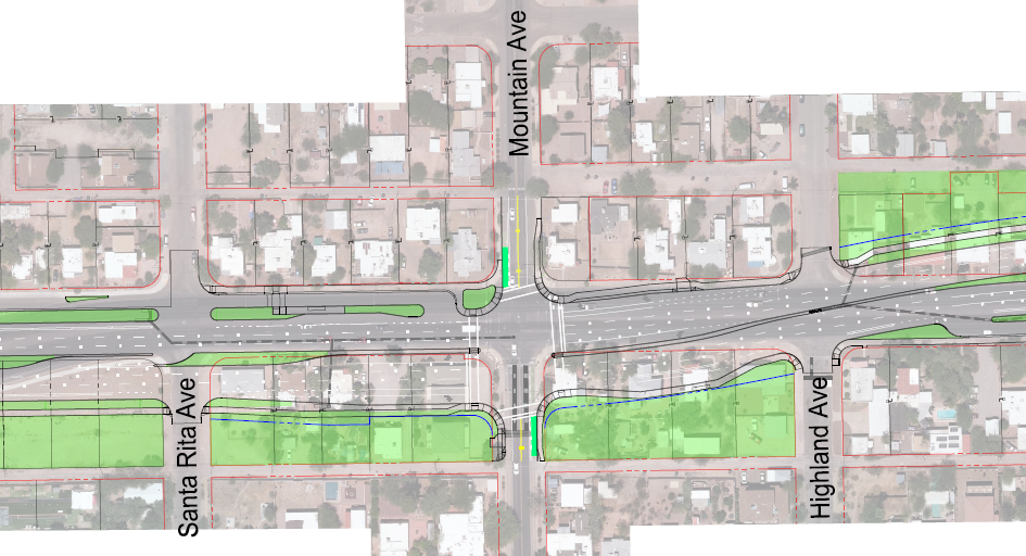
Grant Road 5/6 Plans are considering a "Dutch Intersesction" at Grant and Mountain. See one in action at: https://m.youtube.com/watch?v=FlApbxLz6pA
PHASES 5/6 IN 30% PLANNING STAGES NOW
Grant Road Coalition resumes its advocacy
See minutes, meetings, documents relating to Phases 5 and 6 at
http://www.grantroadcoalition.com/correspondence-minutes.html
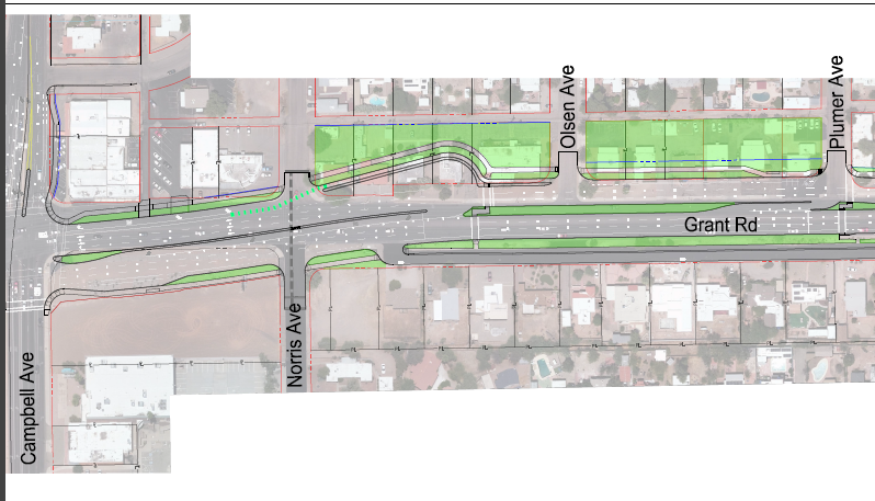
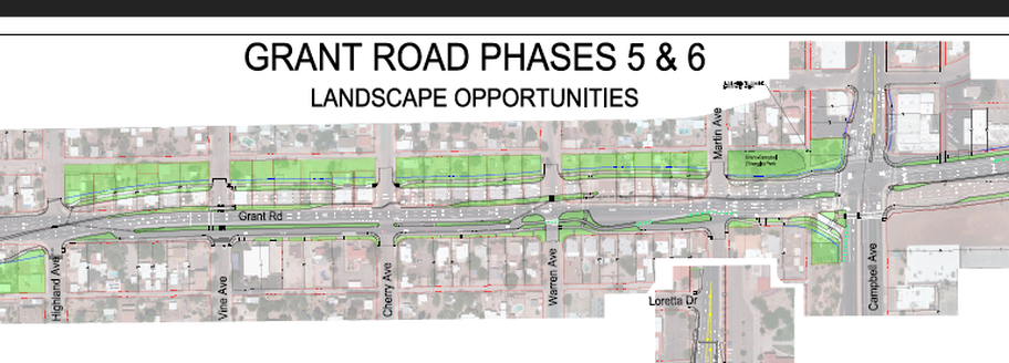
30% PLANS FOR GREENSPACE NORTH SIDE OF GRANT ROAD-Campbell to Plumer
Addresses 2100 and 2200 on Spring Street will be exposed to Grant Road
Addresses 2100 and 2200 on Spring Street will be exposed to Grant Road
30% PLANS FOR GREENSPACE SOUTH SIDE OF GRANT ROAD
Addresses 1300 to 1400 on Edison will be exposed to Grant Road
Addresses 1300 to 1400 on Edison will be exposed to Grant Road
30% PLANS FOR GREENSPACE NORTH SIDE OF GRANT ROAD to Campbell
Addresses 1500 -1900 on Spring Street will be exposed to Grant Road
Addresses 1500 -1900 on Spring Street will be exposed to Grant Road
NEW CONCERN FOR THE GRANT ROAD COALITION MEMBERS
Why should GRC be concerned about the proposed TEP power lines? At first TEP was considering many routes. As of the Nov 4 presentation to Mayor and Council the options for the lines is reduced, however, now all options include Grant Road. Two of the options include routes bisecting the Jefferson Park neighborhood. The Campbell route impacts GRC members, Blenman/Elm, Catalina Vista, and Jefferson Park. TEP has not yet decided upon which side of Grant Road will be chosen. This now makes it a concern of GRC members Sugar Hill, SAMOS, Mountain/First, Jefferson Park
Go to the UNDERGROUND TEP tab to see more information, updates and list of contacts
SEE THE PROGRESS TOWARD A LINEAR HEALTH/HERITAGE TRAIL
under "PROPOSALS/PROJECTS" tab
Read the history of grants and partnerships to bring this vision to reality
under "PROPOSALS/PROJECTS" tab
Read the history of grants and partnerships to bring this vision to reality
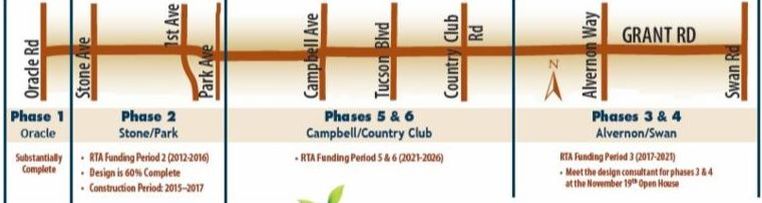
Phases 1 and 2, 2015 - 2018 A history
UA Landscape Graduate class submits first images of Park Concept for Remnants
http://www.jeffersonpark.info/landscapes.html
Six landsacpe designs were created by the graduate class in landscape design taught by Margaret Livingston, Ph.D., Professor of Landscape Architecture, College of Architecture, Planning, and Landscape Architecture. Those were presented at a public meeting Nov 28, 2017. The plans are now posted to the Jefferson Park website, at the link above, for all to see and comment upon.
TIMING FOR THE CENTRAL SEGMENTS and CENTRAL CENTERS will happen in two different time frames.
- Phase 2 -2015 to 2018, from Stone to just east of Park (Santa Rita) which impacts Jefferson Park Neighborhood
- Phase 5/6 - from Santa Rita to Country Club which impacts Jefferson Park again, and SAMOS, Campbell/Grant, and Catalina Vista neighborhoods may not begin until 2026! (per Grant Road Task Force Meeting Oct 19, 2017)
THE GREAT WIDENING - A SLIDE SHOW- This power point was created by S. Studd, of Mountain/First neighborhood. it was presented on August 22 to neighbors and stakeholders who wanted to review what has happened in the past 2+ years of neighborhood involvement in the Grant Road widening process. Published for your review below.
Karin's Uhlich's e-mail of support for the Linear Trail to Tucson Mayor and City Manager!!!
(July 16, 2017) Regarding our ongoing conversation and next steps for the park space along Grant road, I want to update you and confirm the City's support:
1) PAG is continuing to work with us on funds for the Heritage and Health trail (involving Banner, Jefferson Park and area neighborhoods; we need to sustain the City's commitment (already approved as an exception by RTA/PAG given City plans to keep it as Park) to HOLD AND NOT MARKET/SELL the remnants between 1st and Campbell (Tucson) as leverage for the project. While the National Parks grant did not come through, there are opportunities for funding (state and federal) that are being pursued.
2) see below; the State Dept of Forestry has encouraged applications from PAG/City/JP. The first small grant proposal is next FRIDAY under their TREES program and must be submitted under the auspices of the City. JP is drafting and we will get that to Mike's office to submit (I am assuming no other City proposals are in the queue; let me know)
3) PAG/Farhad has agreed to serve as lead and submitter of other proposals (with City as key supporter/collaborator.
Could you please confirm through a reply to this email that this will be our plan moving forward? Through we did not secure the National Parks Grant we can also resubmit next year and it is clear we can identify other potential funding sources to fulfill the exciting and meaningful vision for this area. I know we share the desire to demonstrate that corridor redevelopment can be integrated with appropriate land use that preserves value and enhances quality of life for urban residents. This project is a valuable chance to enact that principle, in-keeping with both City and RTA goals. Karin